
 You are here: Workshops >> Workshop on Laser Scanning Applications 2015
>> poster
You are here: Workshops >> Workshop on Laser Scanning Applications 2015
>> posterList of Accepted Posters: 13
| 3-d field phenotyping of crops using laser scanning and photogrammetric approaches M. Müller-Linow, B. Janssen, A. Steier, U. Rascher Forschungszentrum Jülich, Institute of Bio- and Geosciences, IBG-2, 52425 Jülich > download abstract | |
| 3D laserscanning - a precise tool for rapid parameterization of plant architecture S. Paulus & T. Dornbusch LemnaTec GmbH, Pascalstraße, Germany > download abstract | |
| Applications of integrated data from airborne, terrestrial and mobile laser scanning A. Warchol University of Agriculture in Krakow, Poland > download abstract > download poster | 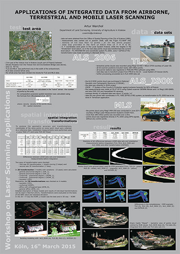 |
| Applying Terrestrial Laserscanning to Continuous Snow Cover Monitoring in an Alpine Environment – A Feasibility Study M.S. Adams, A. Huber & T. Gigele Austrian Research Centre for Forests (BFW), Department of Natural Hazards > download abstract > download poster | |
| Comparing Terrestrial Laser Scanning and UAV-based imaging for geomorphological mapping N. Tilly, D. Kelterbaum, R. Zeese, G. Bareth Institute of Geography, University of Cologne, Germany > download abstract > download poster | 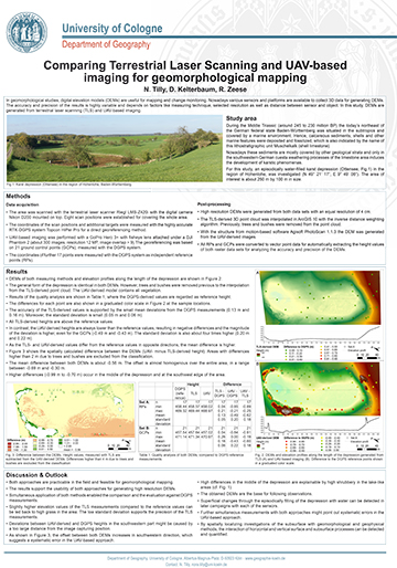 |
| Dense imaging and terrestrial laser scanning for the investigation of dislocated coastal boulders in western Greece D. Hoffmeister (1), C. Curdt (1), R. Röbke (2), A. Vött (2), G. Bareth (1) GIS & RS group, Institute of Geography, University of Cologne, Germany (1), Institute of Geography, Johannes Gutenberg University, Mainz, Germany (2) > download abstract | |
| Detailed photogrammetric feature documentation and cave modelling T. Wolter & O. Vogels Institute of Prehistoric Archaeology, University of Cologne, Germany Collaborative Research Centre 806 "Our Way to Europe" > download abstract | |
| From landscape to miniature – a processing chain from UAV data to a 3D printed model A. Burkart (1), T. Burkart (2), S. von Bueren (3), U. Rascher (1) Institute of Bio- and Geosciences, IBG-2: Plant Sciences, Forschungszentrum Jülich GmbH, Jülich, Germany (1), Technical University Düsseldorf, Düsseldorf, Germany (2), Institute of Agriculture & Environment, Massey University, Palmerston North, New Zealand (3) > download abstract | |
| Investigation and comparison of two innovative low-cost time-of-flight cameras J. C. Rose, J. Behmann, L. Plümer, H. Kuhlmann Institute of Geodesy and Geoinformation, University of Bonn, Germany > download abstract > download poster | 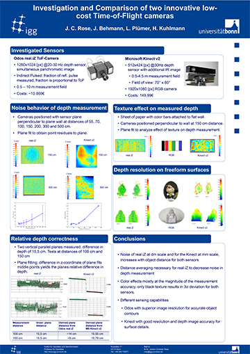 |
| On the geometry and allometry of big buttressed trees – a challenge for forest monitoring: new insights from 3D-modeling with terrestrial laser scanning N. Nölke (1), L. Fehrmann (1), N. S. Jaya (2), T. Tiryana (2), D. Seidel (1), C. Kleinn (1) Chair of Forest Inventory and Remote Sensing, Universität Göttingen, Germany (1), Division of Forestry Planning, Department of Forest Management, Faculty of Forestry, Bogor Agricultural University, Indonesia (2) > download abstract | |
| Terrestrial 3D laser scanning to analyse canopy growth of maize (Zea mays), soybean (Glycine max) and wheat (Triticum aestivum) under field conditions M. Friedli, N. Kirchgessner, C. Grieder, F. Liebisch, M. Mannale, A. Walter Institute of Agricultural Science, Crop Science Group, ETH Zürich, Switzerland > download abstract | |
| Tree modelling of forest regions from TLS data P. Raumonen (1), P. Casella (2), M. Kaasalainen (1), S. Kaasalainen (3) Tampere University of Technology, Finland (1), Forest Research, UK (2), Finnish Geodetic Institute, Finland (3) > download abstract | |
| Urgent Demands within Large Scale ALS/MLS Projects with UAV-based Laser Scanning U. Riegl, P. Amon, P. Rieger, M. Pfennigbauer RIEGL Laser Measurement Systems GmbH, Austria > download abstract > download poster | 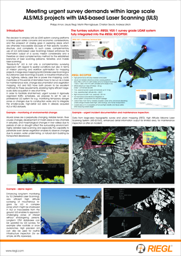 |


