
 You are here: Workshops >> UAV-based Remote Sensing Methods for Monitoring Vegetation >> poster
List of Accepted Posters: 46
| A precise direct georeferencing system for UAVs C. Eling, L. Klingbeil, H. Kuhlmann Institute of Geodesy and Geoinformation, University of Bonn, GERMANY > download abstract | |
| Accurate drought stress detection in commercial citrus orchards through fusion of RPAS and airborne hyperspectral imagery Stephanie Delalieux (1), P.J. Zarco-Tejada (2,3), M.A. A. Jiménez-Bello (4), D.S. Intrigliolo (4) (1) Flemish Institute for Technological Research, BELGIUM. (2) Institutode Agricultura Sostenible (IAS), Consejo Superior de Investigaciones Científicas (CSIC), Córdoba, SPAIN, (3) MARS-GeoCAP, Institute for Environment and Sustainability (IES), Joint Research Centre (JRC), European Commission, Ispra, (VA), ITALY, (4) Instituto Valenciano de Investigaciones Agrarias (IVIA) , Centro Desarrollo Agricultura Sostenible, Moncada, Valencia, SPAIN > download abstract | |
| An Adaptive Texture Selection Framework for Ultra-high Resolution UAV Imagery J. Kelcey, A. Lucieer School of Geography and Environmental Studies, University of Tasmania, AUSTRALIA > download abstract | |
| An experiment with an UAV enabled hyperspectral matrix camera and a portable full range field spectroradiometer A. Jung (1), M. Vohland (1), R. Graser (2), R. Michels (2) (1) University of Leipzig, GERMANY, (2) Cubert GmbH, Ulm, GERMANY > download abstract | |
| Application of an Airborne Remote Sensing Platform for High Throughput Phenotyping of Wheat Crops M. Tattaris, M. Reynolds, J. Pietragalla, G. Molero, M. Ellis, C.M. Cossani CIMMYT, International Maize and Wheat Improvement Center, MEXICO > download abstract | |
| Assessment of grapevine leaf and canopy vigour properties by quadrocopter-carried VIS/NIR mul-tispectral camera R. Retzlaff (1), D. Molitor (2), M. Behr (2), T. Wantzenrieder, L. Hoffmann (2), D. Evers (2), T. Udelhoven (1,2) (1) Institute of Environmental Remote Sensing and Geoinformatics, University of Trier, GERMANY, (2) Department Environment and Agro-biotechnologies, LUXEMBOURG > download abstract > download poster | 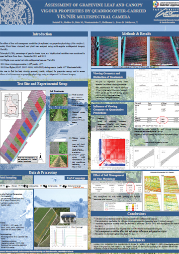 |
| Automated Calculation and Stability Analysis of Common Vegetationindices with HyperCor – first results H. Aasen University of Cologne, Institute of Geography, GIS & RS Group, GERMANY > download abstract | |
| Automated plant parameterizing using high precision laserscanning and geometry based surface classification S. Paulus, H. Kuhlmann Institute for Geodesy and Geoinformation, University of Bonn, GERMANY > download abstract | |
| Automatic Co-registration of Frame Hyperspectral Data from UAVs M. Vakalopoulou, K. Karantzalos Remote Sensing Laboratory, National Technical University of Athens, GREECE > download abstract | |
| Characteristics of consumer-grade cameras for multi-spectal vegetation monitoring with ultra-light UAVs R. de Jong (1), W. Nijland (2), H. Torabzadeh (1), A. Hueni (1) and M. E. Schaepman (1) (1) Remote Sensing Laboratories, University of Zurich, SWITZERLAND, (2) Dept. of Forest Resource Management, University of British Columbia, CANADA > download abstract | |
| Classification of riparian forest species (individual tree level) using UAV-based Canopy Height Model and multitemporal orthophotos (Vielsalm, Eastern Belgium) M. Adrien, J.Lisein, F. Toromanoff, P. Lejeune, C. Hugues University of Liege - Gembloux Agro-Bio Tech. Unit of Forest and Nature Management, BELGIUM > download abstract > download poster | 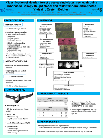 |
| Comparison of narrow band vegetation indices and empirical models from hyperspectral remote sensing data for the assessment of wheat nitrogen concentration B. Siegmann (1), T. Jarmer (1), H. Lilienthal (2), N. Richter (2), T. Selige (3), B. Höfle (4) (1) Institute for Geoinformatics and Remote Sensing, University of Osnabrueck, GERMANY, (2) Julius Kühn-Institut, Institute for Crop and Soil Science, GERMANY, (3) Institute of Soil Ecology, TU Munich, GERMANY, (4) Institute of Geography, University of Heidelberg, GERMANY > download abstract | |
| Construction and Measurement Technology of the ThuenoCopter for Contactless Inspection of Crop Canopies: First Measurements with a Low Cost Image Analyzing System H. Neeland, M. Kraft Thünen Institute of Agricultural Technology, Braunschweig, GERMANY > download abstract | |
| Crop drought monitoring using NDVI and NDWI indices in Southern part of Romania A. T. Nertan, A. Irimescu, D. Mihailescu, V. Stefanescu National Meteorological Administration, ROMANIA > download abstract | |
| Crown area allometries for surveying blossoming wild cherry with unmanned aerial system (UAS) J. Lisein, A. Michez, S. Bonnet, P. Lejeune University of Liege - Gembloux Agro-Bio Tech. Unit of Forest and Nature Management, BELGIUM > download abstract > download poster | 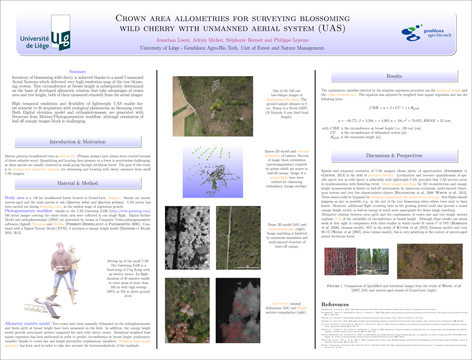 |
| Density estimation of the sugar beet nematode Heterodera schachtii from hyperspectral signatures of canopies K. Schmidt (1), B. Fricke (2), M. Daub (3) (1) Nemaplot, Bonn, GERMANY, (2) INRES-Plant Nutrition, University of Bonn, GERMANY, (3) Julius Kühn Institut, Institute for Plant Protection in Field Crops and Grassland, Elsdorf, GERMANY > download abstract | |
| Derivative analysis to improve rice biomass estimation at early growth stages M. L. Gnyp (1,4), Y. Miao (2,4), F. Yuan (3,4), K. Yu (1,4), Y. Yao (2,4), S. Huang (2,4), G. Bareth (1,4) (1) Institute of Geography, University of Cologne, GERMANY, (2) College of Resources and Environmental Science, China Agricultural University, CHINA, (3) Department of Geography, Minnesota State University, USA, (4) ICASD-International Center for Agro-Informatics and Sustainable Development > download abstract > download poster | 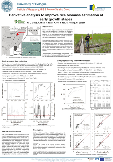 |
| Detection of phytopthora leaf fall disease in rubber plantation usig nmini drone: preliminary results K.Charoenjit (1)(2) , S. Pattanakiat (2) (1) Faculty of Geo-infSaormatics, Burapha University, THAILAND, (2) Geo-informatics in Resource and Environment Research and Training center (GIREN-RTC), Faculty of Environment and Resource studies, Mahidol University Puttamonthon, THAILAND > download abstract > download poster | 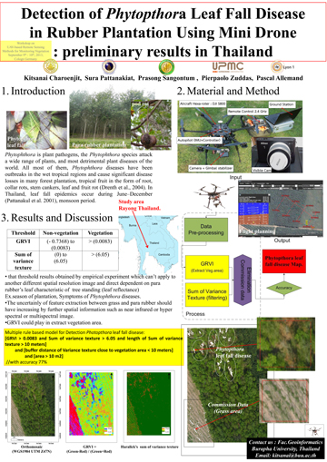 |
| Echo digitizing LIDAR systems for UAV-based vegetation mapping U. Riegl, P. Rieger, M. Pfennigbauer, A. Ullrich RIEGL Laser Measurement Systems GmbH, GERMANY > download abstract > download poster | 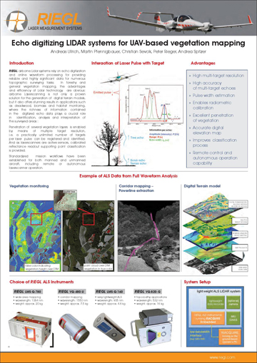 |
| Environmental change detection using hyperspatial and hypertemporal data captured using unmanned aerial vehicles (UAV) in the context of coastal erosion S. Harwin, A. Lucieer School of Geography and Environmental Studies, University of Tasmania, AUSTRALIA > download abstract | |
| Fusion of hyperspectral images and 3D point clouds for undistorted high precision plant imaging J. Behmann (1), S. Paulus (1), A.-K. Mahlein (2), E.-C. Oerke (2), H. Kuhlmann (1), L. Plümer (1) (1) Institute for Geodesy and Geoinformation, University of Bonn, GERMANY, (2) Institute of Crop Science and Resource Conservation, University of Bonn, GERMANY > download abstract > download poster | 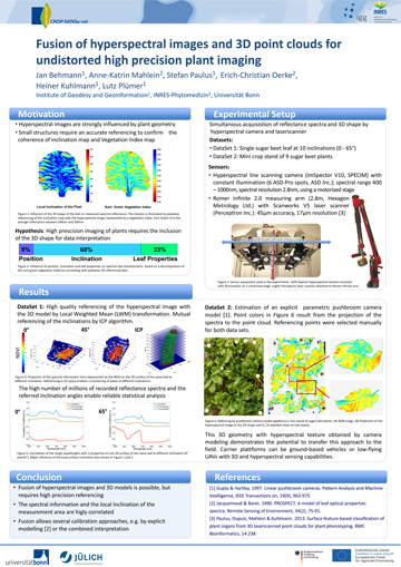 |
| Generation of very high resolution crop surface models (CSMs) using a low-cost UAV system: A method of plant height and biomass monitoring J. Bendig University of Cologne, Institute of Geography, GIS & RS Group, GERMANY > download abstract > download poster | 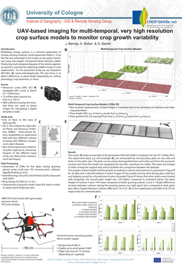 |
| High-frequency crop monitoring using a light-weight hyperspectral mapping system for unmanned aerial vehicles L. Kooistra (1), J. Suomalainen (1), S. Iqbal (2), J. Franke (3), P. Wenting (1), H. Bartholomeus (1), R.Becker (3) (1) Laboratory of Geo-Information Science and Remote Sensing, Wageningen University, THE NETHERLANDS, (2) Hochschule-Rhein-Waal, GERMANY, (3) Alterra, THE NETHERLANDS > download abstract | |
| High-resolution hyperspectral and thermal imagery acquired from UAV platforms for early detection of Verticillium wilt using fluorescence, temperature and narrow-band indices R. Calderón, J. A. Navas-Cortés, C. Lucena, P. J. Zarco-Tejada Instituto de Agricultura Sostenible (IAS), Consejo Superior de Investigaciones Científicas (CSIC), Córdoba, SPAIN > download abstract | |
| Hyperspectral and metabolic profiling of diseased sugar beet leaves A.-K. Mahlein (1), R. Krechel (2), M. Wimmer (2), H. Goldbach (2), U. Steiner (1), E.-C. Oerke (1) (1) INRES-Phytomedicine, University of Bonn, GERMANY, (2) INRES-Plant Nutrition, University of Bonn, GERMANY > download abstract | |
| Introducing a novel miniaturized high performance spectrometer to measure vegetation using an octocopter A. Burkart (1), S. Von Bueren (2), S. Cogliati (3), L. Alonso (4), U. Rascher (1) 1IBG-2: Plant Sciences, Research Center Juelich, GERMANY, (2) Institute of Natural Resources (INR), Massey University, Palmerston North, NEW ZEALAND, (3) Remote Sensing of Environmental Dynamics Laboratory, DISAT, Università degli Studi Milano-Bicocca, ITALY, (4) LEO Group, IPL, University of Valencia, SPAIN > download poster | 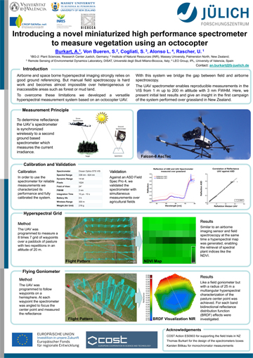 |
| Introducing the Trimble UX5 and TBC Photogrammetry for unmanned airborne vegetation monitoring K. Pauly Gatewing - a Trimble Company, BELGIUM > download abstract > download poster | 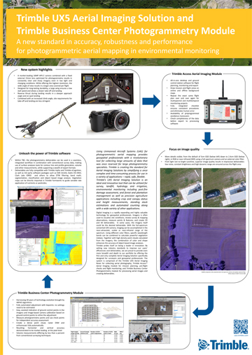 |
| Investigation of Antarctic moss beds using high spatial resolution imaging spectroscopy Z. Malenovsky (1), A. Lucieer (1), S. Robinson (2), T. Veness (1), D. Turner (1) (1) School of Geography and Environmental Studies, University of Tasmania, AUSTRALIA, (2) Institute for Conservation Biology, University of Wollongong, AUSTRALIA > download abstract | |
| Laser Scanning for 3D Vegetation Characterization: Web-based Infrastructure for Exploration and Analysis of Vegetation Signatures K. Koenig, A. Kiefer, B. Höfle Institute of Geography, University of Heidelberg, GERMANY > download abstract | |
| Local Remote Sensing For Precision Agriculture Through Unmanned-Airborne- Vehicles (UAVs) W. Shahid Qureshi, N. Shakya, M. N. Dailey, M. Ekpanyapong Vision and Graphics Lab, School of Engineering and Technology, Asian Institute of Technology, THAILAND > download abstract | |
| Mapping Density of Harvest Residues from Terrestrial Laser Scanning and RGB Imagery K. Koenig (1), B. Höfle (1) , L. Müller (1), M. Hämmerle (1), T. Jarmer (2), B. Siegmann (2), H. Lilienthal (3) (1) Institute of Geography, University of Heidelberg, GERMANY), (2) Institute for Geoinformatics and Remote Sensing, University of Osnabrueck, GERMANY, (3) Julius Kühn-Institut, Institute for Crop and Soil Science, GERMANY > download abstract | |
| Mapping High Arctic plant communities on Svalbard S. R. Karlsen (1), R. Storvold (1), B. Johansen (1), K.-S. Johansen (1), H. Tommervik (2), D. Joly (3), A. Zmarz (4) (1) Northern Research Institute (Norut), NORWAY, (2) Norwegian Institute for Nature Research (NINA), NORWAY, (3) THeMA, CNRS, Universite de Franche-Comte, Besancon cedex, FRANCE, (4) Department of Geoinformatics and Remote Sensing, University of Warsaw, POLAND > download abstract | |
| Monitoring of a landslide using ultra-high resolution UAV imagery D. Turner, A. Lucieer School of Geography and Environmental Studies, University of Tasmania, AUSTRALIA > download abstract | |
| On the concept of a multi-scale integrated environmental monitoring system for South Tyrol A. Vilardi (1), C. Notarnicola (1), E. Tomelleri (1,2), M. Zebisch (1) (1) Institute for Applied Remote Sensing, EURAC Research, ITALY, (2) Max-Planck-Institute for Biogeochemistry, Jena, GERMANY > download abstract > download poster | 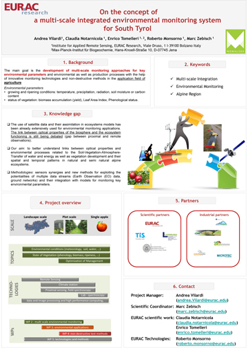 |
| One step up - Large scale field spectroscopy from UAVs on vegetation A. Burkart, U. Rascher Forschungszentrum Juelich GmbH, Plant Sciences (IBG-2), GERMANY > download abstract > download poster | |
| Rikola Frame-Based Hyperspectral Camera. Results from UAV Measurement Campaigns J. Soukkamäki (1), S. Heikki (2), E. Honkavaara (3), I. Pölönen (4), J. Kaivosoja (5) (1) Rikola Ltd., Oulu, FINLAND, (2) VTT Photonic devices and measurement solutions, Espoo and Oulu, FINLAND, (3) Finnish Geodetic Institute, Kirkkonummi, FINLAN, (4) University of Jyväskylä, Jyväskylä, FINLAND,(5) MTT - Agrifood Research Finland, Vihti, FINLAND > download abstract | |
| Terrestrial laser scanning for precise plant height measurement and biomass estimation of barley - visualized in multi-temporal Crop Surface Models N.Tilly, D.Hoffmeister, H. Aasen, J. Brands G. Bareth University of Cologne, Institute of Geography, GIS & RS Group, GERMANY > download abstract > download poster | 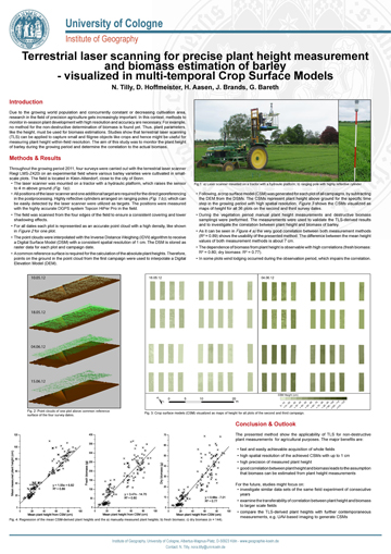 |
| The design philosophy of a robust and adaptable multi-rotor UAV for ultra-high resolution hyperspectral scanning in agricultural remote sensing applications T. Veness, A. Lucieer School of Geography and Environmental Studies, University of Tasmania, AUSTRALIA > download abstract | |
| Transferability of Indices across Multiple Sensors with Differing Spectral Resolutions S. Cundill, H.M.A. van der Werff, M. van der Meijde Faculty of Geo-Information Science and Earth Observation (ITC), University of Twente, THE NETHERLANDS > download abstract > download poster | 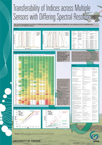 |
| UAS in Morocco and Belgium - Evaluation of two mapping systems S. d'Oleire-Oltmanns (1), F. Van Coillie (2) , W. Hantson (3) (1) Department of Geoinformatics - Z_GIS, Salzburg, AUSTRIA, (2) Laboratory of Forest Management and Spatial Information Techniques - FORSIT, Ghent University, BELGIUM, (3) Avia-GIS, Zoersel, BELGIUM > download abstract | |
| UAV-borne LiDAR for forest management L. Wallace, A. Lucieer School of Geography and Environmental Studies, University of Tasmania, AUSTRALIA > download abstract | |
| Using area-based spectral indices to estimate aerial N uptake of maize F. Li (1) (2), Y. Miao (2) (3), X. Chen (2) (3) (1) College of Ecology & Environmental Science, Inner Mongolia Agricultural University,CHINA, (2) Intefornational Center for Agro-Inrmatics and Sustainable Development, CHINA, (3) Center for Resources, Environment and Food Security, China Agricultural University, CHINA > download abstract | |
| Using partial least squares (PLS) to estimate canopy nitrogen and biomass of paddy rice in China's Sanjiang Plain K. Yu (1, 2, 3), M. L.Gnyp (1, 3), X. Chen (2, 3), Y. Miao (2, 3), G. Bareth (1, 3) (1) Institute of Geography, University of Cologne, GERMANY, (2)Center for Resources, Environment and Food Security, China Agricultural University, CHINA, (3) International Center for Agroinformatics and Sustainable Development > download abstract > download poster | 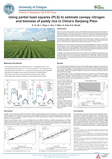 |
| Using UAV based thermal imaging for monitoring spring development of blackcurrant (Ribes nigrum) K. Kusnierek, A. Korsaeth, A. Sonsteby Bioforsk - Norwegian Institute for Agricultural and Environmental Research, NORWAY > download abstract | |
| Using UAV for site-specific weed management in early season J. M. Pena, J. Torres-Sánchez, A.I. de Castro, F. López-Granados Institute for Sustainable Agriculture, CSIC, Córdoba, SPAIN > download abstract | |
| Vegetation parameter estimation using unmanned aerial vehicles: a sensor comparison S. von Bueren (1), A. Burkart (2), I. Yule (1) (1) Massey University, NEW ZEALAND, (2) Research Centre Jülich, GERMANY > download abstract |


